


By Sorie Sesay
The Ministry of Lands, Housing and Country Planning has announced the installation of 13 Continuous Operating Reference Stations (CORS) across Sierra Leone in a landmark move aimed at addressing widespread land disputes and improving surveying accuracy.
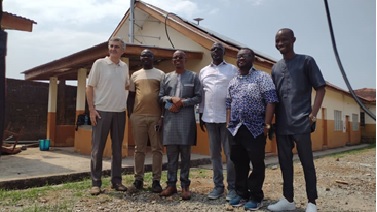
The announcement was made during a press briefing held at the Moyamba Government Hospital, where one of the new CORS stations has been installed. Leading the event, Minister of Lands Dr. Turad Senesie emphasized the significance of the project in transforming land administration in the country.
“Over the years, the ministry has faced countless land conflicts due to inaccurate and overlapping surveys,” said Dr. Senesie. “This technology is a game-changer. It will provide centimeter-level accuracy for all land surveys conducted in Sierra Leone, reducing disputes and enhancing land registration processes.”
The CORS stations, which utilize advanced GPS technology, are designed to deliver precise geospatial data in real-time. Once fully operational, the system will support surveyors and other professionals by offering highly accurate positional information accessible from anywhere in the country using GPS receivers.
Director of Surveys and Lands, Mr. Tamba Sahr Dauda, explained the technical benefits: “These stations will allow surveyors to connect from anywhere in the country. Once connected to any of the 13 stations, the device will provide positioning data accurate to within centimeters. This ensures that wherever a person stands, the location data they receive is exact.”
The installation in Moyamba is one of several across the country, with each site carefully chosen to ensure optimal coverage and functionality. According to project consultant and service provider Zdenko Kurtevic, also known as “Kuzo,” the CORS stations are built to withstand power outages and harsh weather conditions.
“What you see here is a three-component system,” Kurtevic said. “It includes a rooftop antenna connected via GPS cable, a high-speed internet ‘Star’ antenna for data transmission, and an internal unit that remains to be installed. Even during prolonged power outages, the system can function for up to five days.”
Upon completion, Sierra Leone will become a regional leader in geospatial technology, with the most advanced CORS infrastructure among its West African neighbors.
The Ministry has pledged to ensure the proper implementation and maintenance of the system, positioning it as a critical tool in national development, land governance, and urban planning.